Building plan (Kanakapura Planning Authority)Sanctioned 12 Sep 2024No. LAO/196/2023-24/1411
RERA extensionsNone on the filingFiling read 20 Oct 2026
Land conversionConverted 25 Apr 2017DC OFFICE
Permits
Approval letters
Building plan (Kanakapura Planning Authority)
Sanctioned 12 Sep 2024 · No. LAO/196/2023-24/1411
Power NOC
Filed with the registration
SEIAA
Filed with the registration
Disputes & cases
Are there court cases or buyer complaints on this project?
Locked
Cases on the land
Cases on the builder
RERA complaints
Builder's other projects
Filed onCase no.Filed atWhat it's aboutStatus
₹ ••,•••
•• %
•• ••• ••••
Contract & costs
What does a buyer commit to?
We haven't verified this for this project yet.
Sign in first, then it is one click.
Not verified yet: Forfeiture, agreement; Forfeiture, allotment letter; Transfer fee; Maintenance included; Agreement and allotment letter; Payment plan; Agreement for sale.
Valuation
What is it worth?
We haven't verified the rest of this yet.
Sign in first, then it is one click.
This project
Unit sizes
Floor plans, brochure
No floor plans on file
The area
Unsold stock nearby
Months to sell unsold stock
Location & risks
What is the location like?
Groundwater, taluk average16.9 m below groundBengaluru South taluk, July 2023
Water supply, as filedLocal authority (PANCHAYATH)Declared by the promoter
Metro, operationalabout 2.5 kmJaya Prakash Nagar
Construction & progress
How is it being built, and when will it be ready?
Clear1 clear
Completion100%As of Q4 2025-26, promoter's return
Progress
Completion, as the promoter reported it
Developer
Can the developer deliver?
Receivable, sold plots₹8.45 CrAs of Q4 2025-26
Cost left₹88.3 LAs of Q4 2025-26
Sold21 bookedAs of Q4 2025-26
Funding
Estimated cost
Loan & collateral
Can it be financed?
Developer's project loanNo borrowing declaredAs declared in the K-RERA filing
Conditions
Collateral checks
Developer's project loan
No borrowing declared
Building plan
Sanctioned 12 Sep 2024
Escrow bank
HDFC · KUMARASWAMY LAYOUT
Stage
Progress as reported, by quarter
Data room
Documents filed for this project
Locked
116 documents filed with K-RERA for this project
DocumentFolderPagesFiled
₹ ••,•••
•• %
•• ••• ••••
•••••
₹ •.•• Cr
•• of ••
₹ ••,•••
•• %
Unlock this full report
₹99 for this report opens Title & ownership, Disputes & cases and Documents for this project, yours to read for good.
Unlock this full report₹99 for this report · opens Title & ownership, Disputes & cases and DocumentsUnlock
Survey plots · KGIS cadastral
Imagery: Esri, Vantor, Earthstar Geographics
Survey plots around an approximate filed pin, with its uncertainty ring, on satellite imagery. The outlines are the land of each survey number, not buildings. Survey plots around an approximate filed pin. The dashed ring is 1 km: nine in ten approximate pins checked against surveyed land sat within it, so the site is most likely somewhere inside it, not at its centre. This project's survey numbers are not matched to the plots yet, so none is marked as its land.
Survey plots, KGIS cadastral
Road, stream, tank or settlement (not a plot)
Approximate location: the filed pin, good to the neighbourhood, not the plot
Everything here is as filed by the promoter with Karnataka RERA or as recorded in Bhoomi land records, and can be stale or wrong at source. Verify against certified records before you transact. Open Aspire Calixia in the interactive atlas
•• ••• ••••
Title
Title report
•• %
•• ••• ••••
•••••
₹ •.•• Cr
Charges
•• ••• ••••
•••••
₹ •.•• Cr
•• of ••
Boundaries
Schedule in the EC vs KGIS neighbours
Not verified yet
Encumbrance certificate, Form 15
Survey sketch
Survey sketch filed with K-RERA
Sketch, sanction and mutation vs KGIS map
Not verified yet
Land record
Survey plots · KGIS cadastral
Filing vs KGIS map
•• ••• ••••
•••••
₹ •.•• Cr
•• of ••
The RTC of each filed survey
Not verified yet
Ownership
Share of sales revenue
Not verified yet
Joint development agreement
Not verified yet
Unlock this full report
₹99 for this report opens Title & ownership, Disputes & cases and Documents for this project, yours to read for good.
KSPCB
Filed with the registration
Water supply NOC
Filed with the registration
RERA
K-RERA
RERA extensions
None on the filing
RERA completion date
31 Mar 2028
Registration certificates
PRM/KA/RERA/1251/310/PR/170625/007838
Land use
Conversion order
Land conversion
Converted 25 Apr 2017 · DC OFFICE
Survey numbers
2/3 (OLD SY NO 2/1) · 13/7
Not verified yet: Validity, Fire NOC, Airport height NOC.
•••••
₹ •.•• Cr
•• of ••
Unlock this full report
₹99 for this report opens Title & ownership, Disputes & cases and Documents for this project, yours to read for good.
K-RERA inventory
Projects within 4 km, counted
22 (22 with an approximate location)
Plots in them
3,519
Booked
2,320 of 3,519 (66%)
Unsold
1,199
Booked a month, pooled
64 plots
Months to sell, pooled
19 months
Not verified yet: Recent price, plot area; Phase 1 → Phase 2; Gross yield, per sq ft; Price per sq ft, plot area; Form 4 certified totals; Agreements in the Form 4 sold list; Plot area vs rest, by type; Unit mix filed; Unit types; K-RERA inventory; Transactions in this project; South Bengaluru, past year; Bengaluru, past year; South Bengaluru since 2022; This project vs South Bengaluru; By quarter; Registered sale price per sq ft, by year; Transactions around this project; Plot price, plotted layouts within 4 km; Filed prices nearby; Nearest 12 with filed prices; This project vs the nearest with filed prices; Median rent, 3 km; Rents and yields.
The site
Zoning & hazards
Power lines, drains and flood locations around the filed pin
Basemap: Esri, OpenStreetMap contributors
Map of high-tension power lines, storm drains and government-flagged flood locations within about 2 km of an approximate filed pin. Approximate location: the filed pin, good to the neighbourhood, not the plot. The dashed ring is 1 km: of the approximate pins that could be checked against the surveyed land, nine in ten sat within it.
High-tension line, 765, 400, 220 and 66 kV
Its corridor, to scale
Buried cable
Storm drain, primary
Government-flagged flood location
Approximate location: the filed pin, good to the neighbourhood, not the plot
Not verified yet: Possession, agreement; Structure; Structural safety certificate; By component; Internal roads; Club house; Completion, accountant; Schedule end; What the promoter specified · not an inspection; Specification sheet · brands "or equivalent"; Design consultants (Form 6); Fire safety; Environmental clearance.
Land · ₹7.73 Cr 57.3%Development · ₹5.77 Cr 42.7%
Cost left vs buyer dues
Form 4
Estimated cost, at registration
₹13.50 Cr
Cost left
₹88.3 L
Receivable, sold plots
₹8.45 Cr
Sales
K-RERA inventory
Plots booked, Form 4 Q4 2025-26
21
Compliance
Escrow, Q4 2025-26
Escrow and filings
Escrow bank
HDFC · KUMARASWAMY LAYOUT
Designated account, collected
₹67.7 L in Q4 2025-26
Designated account, withdrawn
₹44.9 L in Q4 2025-26 (66% of that quarter's deposits)
Escrow account, Q4 2025-26
Opened at ₹2.0 L, ₹1.0 L other deposits, ₹44.9 L withdrawn
Sale proceeds realised, Q4 2025-26
₹67,71,196
Not verified yet: Sold in the latest quarter; Cost incurred; Collected from buyers; Land cost revision; Sold vs unsold; Sold per quarter; Unregistered agreements, over 10% paid; Average schedule slip; DOSL builder track.
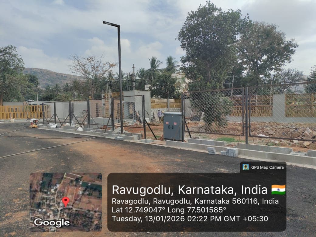
Site photos, Q4 2025-26
Not verified yet: Value; Max loan; Borrower margin; Example unit; Calculation; Records searched to; Unregistered agreements, over 10% paid; Sale deed in favour of.
Basemap: Esri, OpenStreetMap contributors
Map of drains, lakes, metro, high-tension lines and government-flagged flood locations within 3 km of the filed pin, with rings at 3 km. Approximate location: the filed pin, good to the neighbourhood, not the plot. The dashed ring is 1 km: of the approximate pins that could be checked against the surveyed land, nine in ten sat within it.
Storm drain, primary
Lake or tank
Metro lines (dashed: planned)
Metro station
High-tension line, 765, 400, 220 and 66 kV
Its corridor, to scale
Buried cable
Government-flagged flood location
Approximate location: the filed pin, good to the neighbourhood, not the plot
Map of storm drains, lakes and government-flagged flood locations within about 2 km of an approximate filed pin. Approximate location: the filed pin, good to the neighbourhood, not the plot. The dashed ring is 1 km: of the approximate pins that could be checked against the surveyed land, nine in ten sat within it.
Lake or tank
Storm drain, primary
Government-flagged flood location
Approximate location: the filed pin, good to the neighbourhood, not the plot
Bengaluru South taluk average, July 2023: 16.9 m below ground
What it means
10-20 m below ground, a class in CGWB's depth-to-water-level classes. In the pre-monsoon of 2025, 0 of 10 CGWB wells in Bengaluru South taluk read in this class
Through the year
January 2025: 2.2 m (5 wells), Pre-monsoon 2025: 1.9 m (10 wells), August 2025: 1.5 m (11 wells), depth below ground of CGWB's monitoring wells in Bengaluru South taluk (the median where there are several)
Water supply, as filed
Local authority (PANCHAYATH)
Distances
Within 3 km of the filed pin
Basemap: Esri, OpenStreetMap contributors
Map of drains, lakes, metro, high-tension lines and government-flagged flood locations within 3 km of the filed pin, with rings at 3 km. Approximate location: the filed pin, good to the neighbourhood, not the plot. The dashed ring is 1 km: of the approximate pins that could be checked against the surveyed land, nine in ten sat within it.
Storm drain, primary
Lake or tank
Metro lines (dashed: planned)
Metro station
High-tension line, 765, 400, 220 and 66 kV
Its corridor, to scale
Buried cable
Government-flagged flood location
Approximate location: the filed pin, good to the neighbourhood, not the plot