Deputy Commissioner, Bangalore District · Survey 46/1
K-RERA filing, land schedule
Approvals
Is it approved for its use?
Building plan (BBMP)Sanctioned 9 Nov 2023No. BBMP/Addl.Dir/JDNORTH01019/22-23
RERA extensionsNone on the filingFiling read 31 Oct 2026
Land conversionConverted 8 Apr 2022Deputy Commissioner, Bangalore District
Permits
Approval letters
Building plan (BBMP)
Sanctioned 9 Nov 2023 · No. BBMP/Addl.Dir/JDNORTH01019/22-23
Fire department
Filed with the registration
Environmental clearance
Filed with the registration
Disputes & cases
Are there court cases or buyer complaints on this project?
Locked
Cases on the land
Cases on the builder
RERA complaints
Builder's other projects
Filed onCase no.Filed atWhat it's aboutStatus
₹ ••,•••
•• %
•• ••• ••••
Contract & costs
What does a buyer commit to?
We haven't verified this for this project yet.
Sign in first, then it is one click.
Not verified yet: Forfeiture, agreement; Forfeiture, allotment letter; Transfer fee; Maintenance included; Agreement and allotment letter; Payment plan; Agreement for sale.
Valuation
What is it worth?
We haven't verified the rest of this yet.
Sign in first, then it is one click.
This project
Unit sizes
Unit mix filed
Location & risks
What is the location like?
Groundwater, taluk average11.4 m below groundYelahanka taluk, July 2023
Water supply, as filedBWSSBDeclared by the promoter
Metro, operationalabout 12 kmYeshwantpur
Construction & progress
How is it being built, and when will it be ready?
Clear1 clear
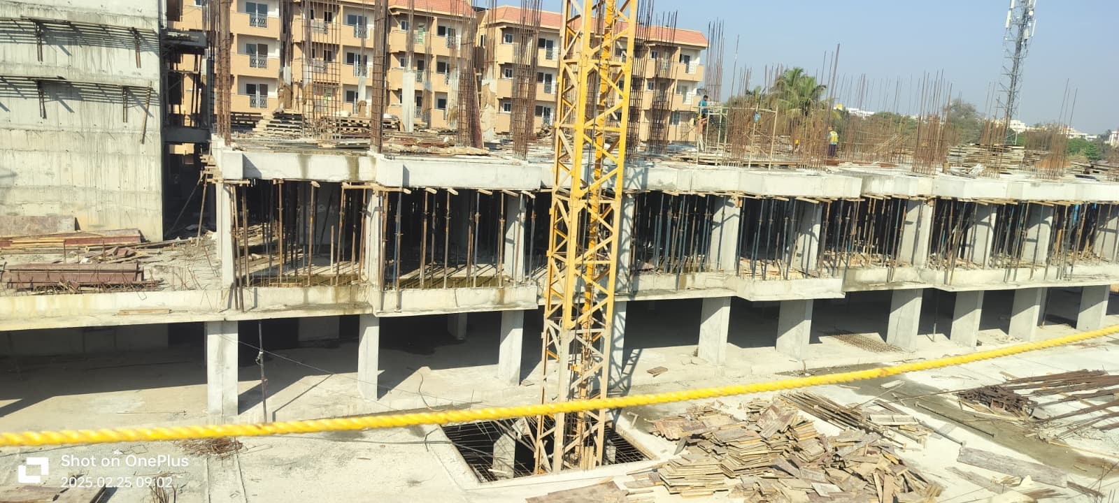
Completion21%As of Q3 2025-26, promoter's return
Progress
Site photos filed with K-RERA, Q3 2025-26
Developer
Can the developer deliver?
Sold28 / 242As of Q3 2025-26
Funding
Estimated cost
Land · ₹4.70 Cr 4.6%Development · ₹97.82 Cr 95.4%
Loan & collateral
Can it be financed?
Developer's project loanNo borrowing declaredAs declared in the K-RERA filing
Conditions
Collateral checks
Developer's project loan
No borrowing declared
Building plan (BBMP)
Sanctioned 9 Nov 2023
Escrow bank
HDFC · Yelahanka Old Town
Stage
Progress as reported, by quarter
Data room
Documents filed for this project
Locked
144 documents filed with K-RERA for this project
DocumentFolderPagesFiled
₹ ••,•••
•• %
•• ••• ••••
•••••
₹ •.•• Cr
•• of ••
₹ ••,•••
•• %
Unlock this full report
₹99 for this report opens Disputes & cases and Documents for this project, yours to read for good.
Unlock this full report₹99 for this report · opens Disputes & cases and DocumentsUnlock
Survey plots · KGIS cadastral
Imagery: Esri, Vantor, Earthstar Geographics
Survey plots around an approximate filed pin, with its uncertainty ring, on satellite imagery. The outlines are the land of each survey number, not buildings. Survey plots around an approximate filed pin. The dashed ring is 1 km: nine in ten approximate pins checked against surveyed land sat within it, so the site is most likely somewhere inside it, not at its centre. This project's survey numbers are not matched to the plots yet, so none is marked as its land.
Survey plots, KGIS cadastral
Road, stream, tank or settlement (not a plot)
Approximate location: the filed pin, good to the neighbourhood, not the plot
Overall, the project looks good and the construction quality seems promising. One thing I really liked is the location. The upcoming metro station is just about 100 meters away, which will make daily travel much more convenient.
VVarshith Kumar13 Jul 2026★★★★★
Visited with my family. We really liked the model home and the project location. The sales team was friendly and never rushed us.
AAmogha Sr10 Jul 2026★★★★★
I visited the construction site today and was very impressed. The layout and progress look great, and team made the decision to book a flat incredibly easy. The entire process was smooth and transparent. I am really looking forward to…
Everything here is as filed by the promoter with Karnataka RERA or as recorded in Bhoomi land records, and can be stale or wrong at source. Verify against certified records before you transact. Open Slv Golden Towers in the interactive atlas
Survey 46/1
Approval or registration
Khata issued
A Khatha · BBMP · Survey 46/1
K-RERA filing, land schedule
2023
Project
Approval or registration
Building plan sanctioned
BBMP · plan BBMP/Addl.Dir/JDNORTH01019/22-23
K-RERA filing, approvals
2024
Project
Approval or registration
RERA registration
PRM/KA/RERA/1251/309/PR/051024/007131
K-RERA registration ·
Approval or registrationThe parcels join the project
Read from the original documentDescribed in the filing or another document; the original is not read here
Title
Charges
Developer's project loan
None declared
Survey sketch
Survey sketch filed with K-RERA
Page 1
Page 1 of the survey sketch. Filed with K-RERA: conversion sketch 3_03.
Survey plots around an approximate filed pin, with its uncertainty ring, on satellite imagery. The outlines are the land of each survey number, not buildings. Survey plots around an approximate filed pin. The dashed ring is 1 km: nine in ten approximate pins checked against surveyed land sat within it, so the site is most likely somewhere inside it, not at its centre. This project's survey numbers are not matched to the plots yet, so none is marked as its land.
Survey plots, KGIS cadastral
Road, stream, tank or settlement (not a plot)
Approximate location: the filed pin, good to the neighbourhood, not the plot
Not verified yet: Title opinion; Records searched to; Charges on the land; Landowner share of sales; Title report; Schedule in the EC vs KGIS neighbours; Encumbrance certificate, Form 15; Sketch, sanction and mutation vs KGIS map; Area on the KGIS map; The RTC of each filed survey; Share of sales revenue; Joint development agreement.
Airport height NOC
Filed with the registration
Pollution board (CFE)
Filed with the registration
Water supply NOC
Filed with the registration
RERA
K-RERA
RERA extensions
None on the filing
RERA completion date
1 Apr 2029
Registration certificates
PRM/KA/RERA/1251/309/PR/051024/007131
Land use
Conversion order
Land conversion
Converted 8 Apr 2022 · Deputy Commissioner, Bangalore District
Survey numbers
46/1
Not verified yet: Validity, Power NOC.
•••••
₹ •.•• Cr
•• of ••
Unlock this full report
₹99 for this report opens Disputes & cases and Documents for this project, yours to read for good.
3BHK · avg 101 m² 63.6%2BHK · avg 72 m² 22.7%4BHK · avg 136 m² 9.1%2.5BHK · avg 85 m² 4.5%
Not verified yet: Recent price, super built-up; Recent price, carpet; Phase 1 → Phase 2; Gross yield, per sq ft; Price per sq ft, super built-up; Form 4 certified totals; Agreements in the Form 4 sold list; Carpet vs rest, by type; Transactions in this project; North Bengaluru, past year; Bengaluru, past year; North Bengaluru since 2022; This project vs North Bengaluru; By quarter; Registered sale price per sq ft, by year; Transactions around this project; Carpet price, projects within 4 km; Filed prices nearby; Median rent, 3 km; Rents and yields.
Power lines, drains and flood locations around the filed pin
Basemap: Esri, OpenStreetMap contributors
Map of high-tension power lines, storm drains and government-flagged flood locations within about 2 km of an approximate filed pin. Approximate location: the filed pin, good to the neighbourhood, not the plot. The dashed ring is 1 km: of the approximate pins that could be checked against the surveyed land, nine in ten sat within it.
High-tension line, 765, 400, 220 and 66 kV
Its corridor, to scale
Buried cable
Storm drain, primary
Storm drain, smaller
Government-flagged flood location
Approximate location: the filed pin, good to the neighbourhood, not the plot
Not verified yet: Receivable, sold flats; Cost left; Sold in the latest quarter; Cost left vs buyer dues; Cost incurred; Collected from buyers; Land cost revision; Sold per quarter; Unregistered agreements, over 10% paid; Average schedule slip.
Site photos, Q3 2025-26
Not verified yet: Value; Max loan; Borrower margin; Example unit; Calculation; Records searched to; Unregistered agreements, over 10% paid; Sale deed in favour of.
Basemap: Esri, OpenStreetMap contributors
Map of drains, lakes, metro, high-tension lines and government-flagged flood locations within 3 km of the filed pin, with rings at 3 km. Approximate location: the filed pin, good to the neighbourhood, not the plot. The dashed ring is 1 km: of the approximate pins that could be checked against the surveyed land, nine in ten sat within it.
Storm drain, primary
Storm drain, smaller
Lake or tank
Metro lines (dashed: planned)
Metro station
High-tension line, 765, 400, 220 and 66 kV
Its corridor, to scale
Buried cable
Government-flagged flood location
Approximate location: the filed pin, good to the neighbourhood, not the plot
Map of storm drains, lakes and government-flagged flood locations within about 2 km of an approximate filed pin. Approximate location: the filed pin, good to the neighbourhood, not the plot. The dashed ring is 1 km: of the approximate pins that could be checked against the surveyed land, nine in ten sat within it.
Lake or tank
Storm drain, primary
Storm drain, smaller
Government-flagged flood location
Approximate location: the filed pin, good to the neighbourhood, not the plot
Yelahanka taluk average, July 2023: 11.4 m below ground
What it means
10-20 m below ground, a class in CGWB's depth-to-water-level classes. In the pre-monsoon of 2025, 0 of 1 CGWB wells in Yelahanka taluk read in this class
Through the year
January 2025: 3.8 m (1 well), Pre-monsoon 2025: 3.4 m (1 well), August 2025: 0.1 m (1 well), depth below ground of CGWB's monitoring wells in Yelahanka taluk (the median where there are several)
Water supply, as filed
BWSSB
Distances
Within 3 km of the filed pin
Basemap: Esri, OpenStreetMap contributors
Map of drains, lakes, metro, high-tension lines and government-flagged flood locations within 3 km of the filed pin, with rings at 3 km. Approximate location: the filed pin, good to the neighbourhood, not the plot. The dashed ring is 1 km: of the approximate pins that could be checked against the surveyed land, nine in ten sat within it.
Storm drain, primary
Storm drain, smaller
Lake or tank
Metro lines (dashed: planned)
Metro station
High-tension line, 765, 400, 220 and 66 kV
Its corridor, to scale
Buried cable
Government-flagged flood location
Approximate location: the filed pin, good to the neighbourhood, not the plot