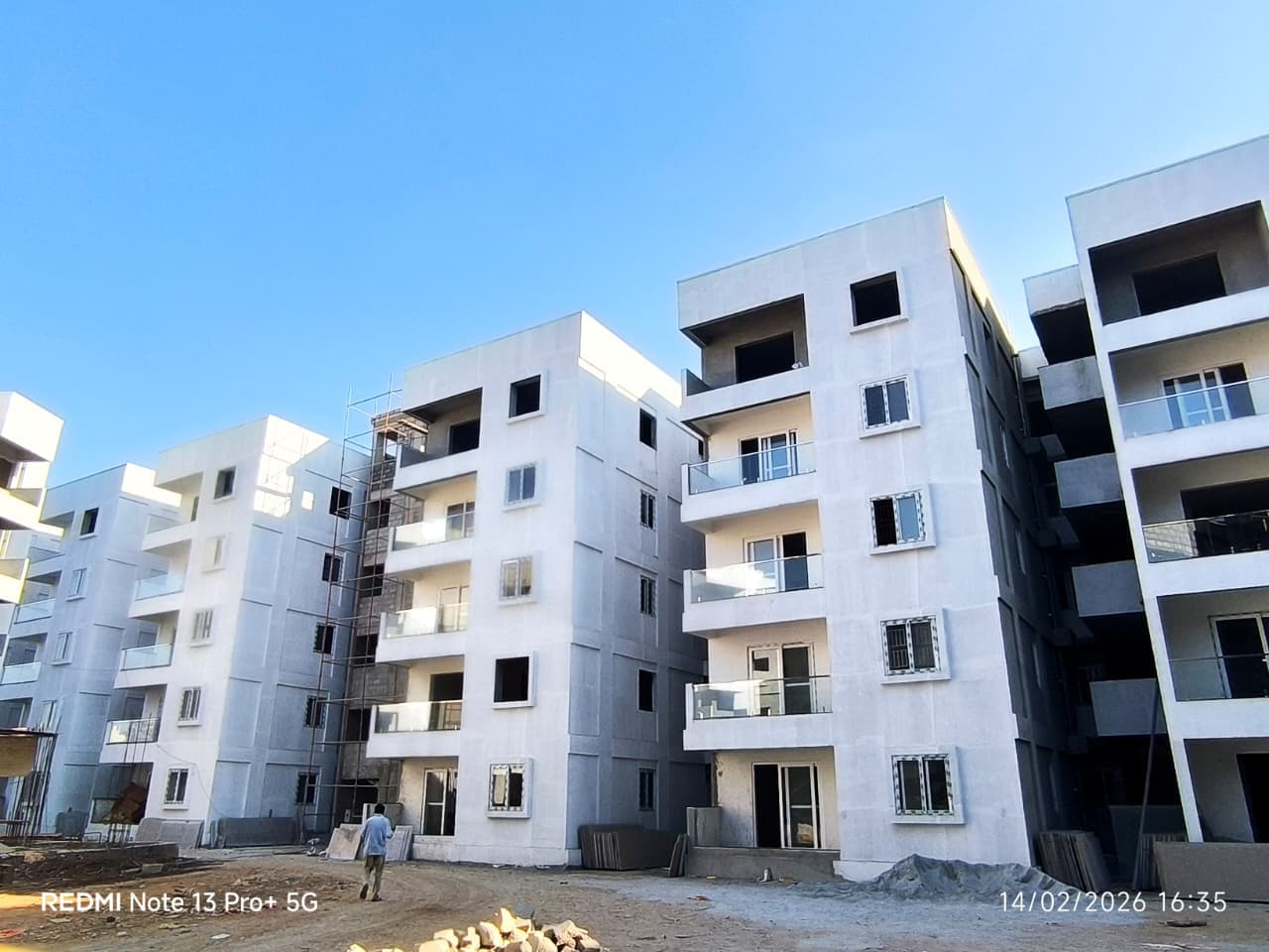
Our experience with Subram Jade Garden Apartments, Nagasandra, has been truly wonderful from start to finish. The entire team made our home-buying journey smooth, transparent, and stress-free by guiding us through every step with patience…
HHarsha AC2 Jul 2026★★★★★
We had a wonderful experience with Subram Jade Garden Apartments, Nagasandra. The entire team was very supportive throughout our home-buying journey. They explained every aspect of the property clearly and guided us patiently through the…
MMk Squre Table Tennis and cultural academy29 Jun 2026★★★★★
This project is the Best. Visited first time -decided to purchase as I felt my house /all houses are independent with 100% Vasthu.. leading to prosperity of all.. who have taken and will be purchasing.. and just near to Nagasandra metro…
Everything here is as filed by the promoter with Karnataka RERA or as recorded in Bhoomi land records, and can be stale or wrong at source. Verify against certified records before you transact. Open Subram Jade Gardens in the interactive atlas
Page 1
Page 1 of 2 of the encumbrance certificate. Filed with K-RERA: Latest Encumbrance Certificate, 2 pages.
No survey sketch is listed on this phase's K-RERA filing
Land record
Survey plots · KGIS cadastral
Imagery: Esri, Vantor, Earthstar Geographics
Survey plots around an approximate filed pin, with its uncertainty ring, on satellite imagery. The outlines are the land of each survey number, not buildings. Survey plots around an approximate filed pin. The dashed ring is 1 km: nine in ten approximate pins checked against surveyed land sat within it, so the site is most likely somewhere inside it, not at its centre. This project's survey numbers are not matched to the plots yet, so none is marked as its land.
Survey plots, KGIS cadastral
Road, stream, tank or settlement (not a plot)
Approximate location: the filed pin, good to the neighbourhood, not the plot
Not verified yet: Title opinion; Charges on the land; Landowner share of sales; How the land reached this project; Court-case search; High Court order; Charges; Schedule in the EC vs KGIS neighbours; Sketch, sanction and mutation vs KGIS map; Area on the KGIS map; The RTC of each filed survey; Share of sales revenue; Joint development agreement.
Valid as of this reportValidity ended
Approval letters
Power NOC
Filed with the registration
Fire department
Filed with the registration
Environmental clearance
SEIAA 198 CON 2023 · EC identification no. EC24C3801KA5994464N · issued 28 Aug 2024
✓Clear
AAI
Filed with the registration
Pollution board (CFE)
consent order CTE-342800 · issued 3 Apr 2024 · valid until 27 Mar 2029
✓Clear
Water and sewerage NOC (BWSSB)
issued 8 Jan 2025
RERA
K-RERA
RERA extensions
Granted · Approved 30 Oct 2024
RERA completion date
31 Dec 2026
Registration certificates
PRM/KA/RERA/1251/309/PR/210804/004238
EX/PRM/KA/RERA/1251/309/PR/241030/004238
Not verified yet: Building plan, Land conversion, Conversion order.
•••••
₹ •.•• Cr
•• of ••
Unlock this full report
₹99 for this report opens Contract & costs, Disputes & cases and Documents for this project, yours to read for good.
•• %
•• ••• ••••
•••••
₹ •.•• Cr
•• of ••
Payments
Payment plan
Not verified yet
Agreement for sale
•••••
₹ •.•• Cr
•• of ••
₹ ••,•••
•• %
Fees
Agreement for sale
₹ •.•• Cr
•• of ••
₹ ••,•••
•• %
•• ••• ••••
Unlock this full report
₹99 for this report opens Contract & costs, Disputes & cases and Documents for this project, yours to read for good.
Not verified yet: Recent price, super built-up; Recent price, carpet; Phase 1 → Phase 2; Gross yield, per sq ft; Price per sq ft, super built-up; Form 4 certified totals; Agreements in the Form 4 sold list; Carpet vs rest, by type; Unit mix filed; Unit types; Transactions in this project; West Bengaluru, past year; Bengaluru, past year; West Bengaluru since 2022; This project vs West Bengaluru; By quarter; Registered sale price per sq ft, by year; Transactions around this project; Carpet price, projects within 4 km; Filed prices nearby; Median rent, 3 km; Rents and yields.
Power lines, drains and flood locations around the filed pin
Basemap: Esri, OpenStreetMap contributors
Map of high-tension power lines, storm drains and government-flagged flood locations within about 2 km of an approximate filed pin. Approximate location: the filed pin, good to the neighbourhood, not the plot. The dashed ring is 1 km: of the approximate pins that could be checked against the surveyed land, nine in ten sat within it.
High-tension line, 765, 400, 220 and 66 kV
Its corridor, to scale
Buried cable
Storm drain, primary
Storm drain, smaller
Government-flagged flood location
Approximate location: the filed pin, good to the neighbourhood, not the plot
Not verified yet: Structure, Structural safety certificate, Internal roads, What the promoter specified · not an inspection, Specification sheet · brands "or equivalent", Design consultants (Form 6), Fire safety.
Land · ₹1.90 Cr 4.1%Development · ₹45.00 Cr 95.9%
Form 4
Estimated cost, at registration
₹46.90 Cr
Estimated cost, Form 4 Q2 2026-27
₹93.40 Cr
Cost incurred
₹83.12 Cr (89% of the Form 4 Q2 2026-27 estimate)
Sales
Sold vs unsold, Q2 2026-27
Sold (115) 65.7%Unsold (60) 34.3%
Sold per quarter
K-RERA inventory
Sold, Q3 2025-26
103 / 175 · 72 available
Sold, Q4 2025-26
109 / 175 · 66 available
Sold, Q1 2026-27
110 / 175 · 65 available
Sold, Q2 2026-27
115 / 175 · 60 available
Unsold, Q2 2026-27
60
Sold in Q4 2025-26
6
Sold in Q1 2026-27
1
Sold in Q2 2026-27
5
Flats booked, Form 4 Q4 2025-26
109
Compliance
Escrow, Q2 2026-27
Escrow and filings
Escrow bank
HDFC · MILLERS ROAD
Designated account, collected
₹8.20 Cr in Q2 2026-27
Designated account, withdrawn
₹5.76 Cr in Q2 2026-27 (70% of that quarter's deposits)
Amount deposited in the quarter, Form 4
₹4,60,60,000
Amount withdrawable, Form 4
₹70,76,39,101
Net amount withdrawable, Form 4
₹23,07,34,570
Withdrawn from the escrow account to date
₹60,04,31,173
Share of collections deposited in escrow
63%
Sale proceeds realised, Q4 2025-26
₹7,34,40,671
Not verified yet: Receivable, sold flats; Cost left; Cost left vs buyer dues; Collected from buyers; Land cost revision; Unregistered agreements, over 10% paid; Average schedule slip; DOSL builder track.
Site photos, Q2 2026-27
Not verified yet: Value; Max loan; Borrower margin; Developer's project loan; Example unit; Calculation; Building plan; Unregistered agreements, over 10% paid; Sale deed in favour of.
Basemap: Esri, OpenStreetMap contributors
Map of drains, lakes, metro, high-tension lines and government-flagged flood locations within 3 km of the filed pin, with rings at 3 km. Approximate location: the filed pin, good to the neighbourhood, not the plot. The dashed ring is 1 km: of the approximate pins that could be checked against the surveyed land, nine in ten sat within it.
Storm drain, primary
Storm drain, smaller
Lake or tank
Metro lines (dashed: planned)
Metro station
High-tension line, 765, 400, 220 and 66 kV
Its corridor, to scale
Buried cable
Government-flagged flood location
Approximate location: the filed pin, good to the neighbourhood, not the plot
Map of storm drains, lakes and government-flagged flood locations within about 2 km of an approximate filed pin. Approximate location: the filed pin, good to the neighbourhood, not the plot. The dashed ring is 1 km: of the approximate pins that could be checked against the surveyed land, nine in ten sat within it.
Lake or tank
Storm drain, primary
Storm drain, smaller
Government-flagged flood location
Approximate location: the filed pin, good to the neighbourhood, not the plot
Bengaluru North taluk average, July 2023: 22.7 m below ground
What it means
20-40 m below ground, a class in CGWB's depth-to-water-level classes. In the pre-monsoon of 2025, 0 of 7 CGWB wells in Bengaluru North taluk read in this class
Through the year
January 2025: 2.6 m (5 wells), Pre-monsoon 2025: 2.9 m (7 wells), August 2025: 3.2 m (7 wells), depth below ground of CGWB's monitoring wells in Bengaluru North taluk (the median where there are several)
Water supply, as filed
Local authority
Distances
Within 3 km of the filed pin
Basemap: Esri, OpenStreetMap contributors
Map of drains, lakes, metro, high-tension lines and government-flagged flood locations within 3 km of the filed pin, with rings at 3 km. Approximate location: the filed pin, good to the neighbourhood, not the plot. The dashed ring is 1 km: of the approximate pins that could be checked against the surveyed land, nine in ten sat within it.
Storm drain, primary
Storm drain, smaller
Lake or tank
Metro lines (dashed: planned)
Metro station
High-tension line, 765, 400, 220 and 66 kV
Its corridor, to scale
Buried cable
Government-flagged flood location
Approximate location: the filed pin, good to the neighbourhood, not the plot